|
Completed Fieldwork: Field A
|
|
|
Description[Monitoring][Preliminary Results]
|
|
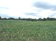
| Catchment geology is dominated by glacial sands and gravels overlying the Upper Chalk. An unsaturated zone of around 20m is present. The heterogeneity of the sands and gravels results in locally perched water tables. Soils range from sandy loam to clay loam boulder clay on the eastern edge of the site. Annual rainfall is approximately 600mm.
|
|
The field has an area of 30 ha with a gently undulating topography. A ditch, with and average width of 2m and depth of 1m, runs from the north east to south west of the site. The ditch passes into a roadside culvert and flows between November and February. One drain is present and drains the south east of the field, entering the ditch at approximately halfway along its length.
|
|
|
To see a larger view of Field A click on the top photo. |
|
|
|
The field received a sludge application of digested sludge and lime stabilised sludge in October 2001. Digested sludge cake was applied at 50 t
ha-1 and lime stabilised sludge was applied at 25 t ha-1. This was equivalent to 1100 mg total P kg-1 and 7000 mg total N
kg-1 for the digested sludge cake and 9000 mg total P kg-1 sludge and 15000 mg total N kg-1 sludge for the lime stabilised sludge. Each treatment was applied separately on adjacent sides of the field.
A control strip where no sludge was applied was implemented to examine the background concentration of nutrients over time.
In November 2004 a further application of digested sludge was made at a rate of 25 t
ha-1, across the whole field.
|