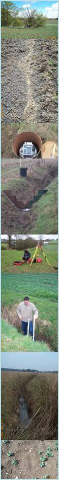
Fieldwork began in autumn 2001 and is currently underway and will continue into 2004/2005 autumn/winter season. The site being studied is within the catchment of the River Stort, near Stansted Mountfitchet, Essex, U.K. Field experiments are underway to define the risk of contaminant transport where hydrological connectivity between land, stream and groundwater exists. The field programme will lead to understanding of the physical dynamics of nutrient transport and hydrology at the field site.
Information on fieldwork can be found by following these links:
[Completed Fieldwork][Current Fieldwork]
The principle aim of the field
programme is to:
- fully understand the
transport to delivery mechanisms for diffuse pollutant loss from land
to receiving waters
- evaluate the spatial
variability in environmental risk from diffuse pollutant (especially
phosphorus, P) sources including biosolids, fertilisers that are
applied to land
- address scaling issues
-
to enable the development
of a generic model linking empirical research at the plot to small
catchment scale - through to river basin
scenario modelling.
This is to be achieved by:
-
performing extensive field surveying using the latest techniques in GPS.
-
pre and post sludge application analysis of soil P and N content to establish areas of nutrient hotspots and identify areas of spare capacity.
-
continuous monitoring of ditch water and soil water levels using constructed flumes and multi level piezometers.
-
continuous monitoring of rainfall.
-
water sampling from ditches, drains and piezometers after application of sludge at varying temporal resolution
-
analysis of water for P and N content.
This data can then be incorporated within the flow connectivity modelling at the catchment scale.
|