|
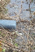
This site was monitored during November 2002 to January 2003. Three drains discharging in to the ditch were sampled. Two of these drain from Field B, which received sludge in 2002. The other drain, in the photo on the left, drained a field that did not receive an application of sewage sludge and acted as a control.
Water samples were collected from October 2002 to January 2003 at least at every 24 hours.
Soil samples were taken prior to and after application. Soil and water were both analysed for nitrogen and phosphorus concentrations. Six nests of piezometers were installed at 1m and 2m depths and monitored to determine groundwater movement at the site.
|