SEAL logo SEAL logo

Critical Source Areas (CSAs)

Critical Source Areas of diffuse pollution occur where land with high nutrient status (high source potential) coincides with areas of significant hydrological connectivity (high transport risk) with receiving waters.

critical source areas diagram

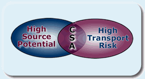
Phosphorus (P) source areas include land of high soil P concentration and areas that reflect land use practices. Hydrological transport processes turn P source areas into P loss areas, however some areas are more vulnerable to P loss than others. It is only when the transport processes occur in P source areas that there is a risk of P loss. An area may have a high P concentration in the soil but without hydrological connectivity no P is transported. In areas with high hydrological connectivity there may be no P transport as there is no link to P source areas.

The agricultural field on the right shows clear evidence of hydrological connectivity between the land and the receiving stream hidden by trees at the base of the slope. Significant sediment and associated P transfer was observed from the CSAs in this field.
The
SEAL Project will use high-resolution digital terrain modelling to identify both natural and man-made CSAs at the hillslope, field and small catchment scales. Flow pathways for fields are identified using high resolution digital maps and hydrological modelling. Examples of this application can be seen on the SEAL field site pages: Field A and Field B.

example of CSA

Photo: Louise Heathwaite
Click on the photo to enlarge

Back to top of page


Lancaster University logo University of Newcastle upon Tyne logo University of Sheffield logo University of Reading logo

© University of Sheffield, University of Newcastle upon Tyne & Lancaster University 2001, 2004 and 2005
Last updated March 2005


Valid HTML 4.0!