Home | Barbados | Antigua | Surinam | Jamaica | Carolina
Surinam
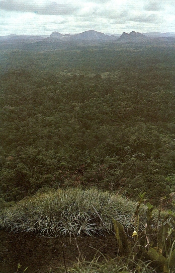 Surinam was the English name for the settlement in mainland south America, known by the Dutch as Suriname, and it can also be referred to as Dutch Guiana, although it gained a degree of autonomy in 1954 and independence in 1975. It lies between the current British Commonwealth state of Guyana, and French Guiana; with Venezuela to the north and west of the Guianas, and Brazil to the south and east. In terms of relief, the Guianas lie along the coast, with the Guiana Highlands in the hinterland, bordered by two mighty rivers. To the north runs the Orinoco, reaching the ocean at a delta, at the point at which the archipelago of Caribbean islands culminates in Trinidad. The Amazon enters the Atlantic in a huge delta north of the Brazilian city of Belém. Much of Surinam is therefore tropical rainforest: getting excited as a 'plane descended over the hinterland into Johan Adolf Pengel International Airport (known as Zanderij International Airport at the time) with a view of thousands of acres across the top of much-vaunted rainforest, the lugubrious Surinamese man in the seat beside me said 'nothing to get excited about: it's only trees for now'. The picture, taken from the southern peaks of the Kassikassima to those of Franssen Herderschee across the jungle, is of a region too far into the hinterland to have formed part of the settlements of either English or Dutch in the seventeenth century.
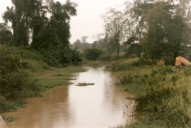
By boat, the English explored their territory, which had been sparsely settled by the Dutch since 1616. After an initial reconnaisance mission in 1650, they travelled along its huge rivers, particularly the Surinam and the Commawena (Commewijne). The coastal plain in the north is largely mangrove and low swamp, much of it below sea level, crossed by creeks, some of which were suitable for travel. Plantations were established along the rivers, also the main means of communication around the territory, and the creek pictured (right) lies in the area in which George Marten had a plantation on the Surinam river.
 The settlement of Surinam, eventually secured under the Lord Proprietorship of the Caribbees, that is under the nominal, or autocratic (depending who was commenting) control of Francis, Lord Willoughby of Parham, was notorious as a lawless and wild place, and was the setting of Aphra Behn's novella, Oroonoko, or the Royal Prince, which described the English settlement in Surinam as a place of cruelty and oppression, and an inversion of the noble values of the eponymous hero, who, although of royal blood, becomes a slaughtered rebel slave in this tropical hell. It is far from clear (and this scholar thinks it unlikely) whether Behn was ever in Surinam, but was, in fact, romanticising the narrative of an English settler who felt his liberties betrayed by the factional governors, whilst, to make the contrast in values more stark, he was given some (but not all) of the features and narrative of an African. It was also written after 1667, when the Dutch gained control of the settlement, when it continued to have a reputation as a wild, lawless and cruel place.
 Although Surinam was the colony, both under the English and the Dutch, which maintained the tradition of being the most cruel and oppressive, the fact that European settlement was confined to the lowlands and the rivers, whilst the interior was dense and unexplored forest, meant that those who escaped their enslavement found refuge, were difficult to trace and recapture and were able to develop a self-contained society which re-created directly, or through folk memory, the life that they had left in Africa. In Suriname, this maroon community is most commonly referred to as the bush negro, and there are five major tribes - Djuka, Saramaccaner, Matuwari, Paramaccaner, and Quinti - though their numbers are greatly depleted after decades of internal strife. There are three major blocks of inhabitants: bush negro in the southern interior; native Americans in the northern interior; and mixed 'settlers' in the coastal plain. The last, beginning with Dutch, then English, then Dutch again, then imported slave labour from Africa and native labour, was joined in the years following Emancipation by waves of indentured labour brought from northern India, north Africa, China, the Middle East and beyond, all of whom mixed to produce the most ethnically-diverse population in the world. With a lull in the unrest at present, and a depressed economy, some attempts are being made to capitalise on the undisturbed nature of Suriname's interior and its complex and exotic past to develop eco-tourism.
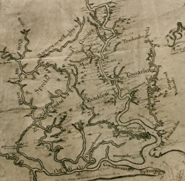
The copy image of the map is a section of the 1667 'Discription of the Coleny of Surranam in Guiana', the original of which, coloured, is held by the John Carter Brown Library. No contemporary maps exist of the English settlement, and this one shows the plantations at the point of the Dutch takeover. The English were inclined to name their plantations after the planters, unlike the Dutch, who, after an initial early period using planters' names were, by the mid-eighteenth century, more likely to call their settlements Glory, Prosperity, Concord, or, more depressingly, 'All is False'.
Anglophone studies of the area are few, and can be divided into three. Firstly, Joyce Lorimer has made several specialist studies of early English exploration of the Guiana coast; Sarah Barber has made a number of studies of the Surinam settlement in the 1650s and 1660s; and literature scholars interested in Aphra Behn have had to engage with the import of her novella of English, native, and African in Surinam.
Links/ Further reading
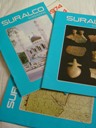 Suriname is rich in bauxite deposits and in 1916 was founded the Surinaamsche Bauxite Maatschappij N.V., which developed solely bauxite until 1958 when it went into partnership with the government to develop hydro-electric power. It became known as the Suriname Aluminium Company, incorporated within the Aluminium Company of America (Alcoa). Since 1974 the company has produced a regular magazine, Suralco, with articles on most issues Surinamese, including several on its history. Issues of the magazine have been available on-line since 2003.
The Archive of early American Images - amongst the electronic and on-line resources of the John Carter Brown Library, Brown University, Providence, Rhode Island. Logging on and access to the collection on-line is free, provided researchers undertake no reproduction without appropriate agreement of the Library. It contains images and excellent editorial details of Guiana documents, including the 1667 map and that of a Dutch copyist which became part of the 'Blathwayt Atlas' compiled between 1680 and 1685 for William Blathwayt, then Secretary to the Committee for Trade and Plantations.
Sarah Barber, A Revolutionary Rogue: Henry Marten and the English Republic (Sutton Publishing, Stroud, 2000), chapter vi, 'Trade and the Sea';
Sarah Barber, 'Power in the English Caribbean: the Proprietorship of Lord Willoughby of Parham', in L.H. Roper and B. van Ruymbeke (eds.), Constructing early-modern Empires: Proprietary Ventures in ther Atlantic World, 1500-1750 (Brill NV, Leiden, 2007);
Aphra Behn, Oroonoko, or the Royal Prince (1688) - a number of criticial editions of this work exist, both in print and as e-texts. Amongst the latter are versions produced by the Universities of Adelaide, Oregon and a link through the 'Colonial and post-colonial literary dialogues' site of the University of Western Michigan.
Maureen Duffy, The Passionate Shepherdess: The Life of Aphra Behn, 1640-1689 (London, 2000);
Joyce Lorimer, 'Untruth and consequences: Raleigh's Discoverie of Guiana and the 'saltings' of the gold mine', The Hakluyt Society Annual Lecture, 2006 (The Hakluyt Society, London, 2007);
Joyce Lorimer, Sir Walter Raleigh's Discoverie of Guiana (The Hakluyt Society, London, 2006);
Joyce Lorimer (ed.), English and Irish Settlements on the river Amazon, 1550-1646 (The Hakluyt Society, London, 1989);
Home | Barbados | Antigua | Surinam | Jamaica | Carolina