Kendal: Early Town Plans
1. John Speed Kendal (1611)
2. John Speed detail of market area
3. John Speed detail of Kirkland area
4. John Owen and Emmanuel Bowen Britannia Depicta (London: 1720)
5. John Cary New Map of England and Wales (London: 1794)
Town Plan of Kendal from the Westmorland map by John Speed
The Theatre of the Empire of Great Britaine (London: John Sudbury & George Humble, 1611-1612).
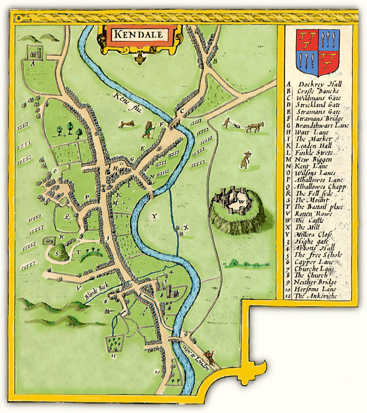
Image © Meg Twycross, based on a facsimile by and © Julie and John Higham,
Souvenir Antiques, Carlisle, with their kind permission.
For a bigger enlargement in its position in the Westmorland map, go to
The Old Cumbria Gazetteer by Martin and Jean Norgate.
This map shows the importance of Kendal as a road hub. The town here is shown as essentially ribbon development along the North/South axis, with
clusters of houses around the market place to the North, and the church (the ward of Kirkland, the ‘Church land’) to the South. Two main stone bridges cross the
River Kent: Stramongate Bridge to the North,
leading to the roads to Sedbergh, Kirby Stephen (the lower branch), and Penrith (the upper branch); and Nether Bridge at the South, carrying the road to Lancaster
and ultimately London. The third bridge, in the middle, was/is Miller Bridge, then a wooden structure that was sometimes swept away.
The road on the west side of the river leads past Dockwray Hall (A) and Burneside through the gap to Windermere and Ambleside, and becomes
the main road through the Lakes to Keswick and Cockermouth. Ogilby describes it as ‘in General as bad a Road as any in England, being very Hilly, Stony and
Moorish, where you seldom meet with that Entertainment as in the more Frequented Roads in the Midle of the Kingdom’.
From Allhallows Lane (P), tracks led over Scout Scar to Underbarrow (the north branch) and Brigsteer (the south). These are not shown on
Speed's map, but they appear in later more detailed ones by Kitchin and Cary.
Return to top
Detail: Market Place area of Kendal from the map by John Speed (1611-1612).
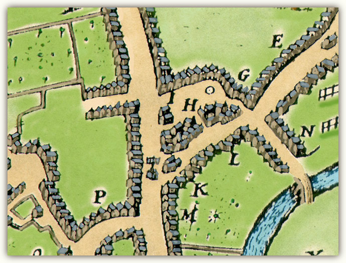
Image © Meg Twycross; credits as above
KEY from Speed’s map: E Stramans Gate; G Brandthwat Lane; H Watt Lane;
I The Market;
K Leaden Hall; L Finkle Street; M New Biggin; N Kent Lane; P Allhallowes Lane.
Lowther Street does not yet exist. The Market Cross stands proud in the middle of Strickland Gate at the end of Finkle Street,
at the head of the rise. It was removed in 1765 because it had become a traffic hazard. The reputed base, called ‘the Ca’ Steean’ or ‘Cauld Steean’ (‘Cold Stone’,
not ‘Calling Stone’),
now stands under the 1893 foundation stone of the Town Hall (see
Visit Cumbria website for photographs). The base appears to be hexagonal. It was used for official proclamations and unofficial preaching.
The drawing suggests that it had a top like that of the market cross at Carlisle.
Miller Bridge, then made of wood, is on the lower right. The fence-like objects in the water-meadows are racks for stretching cloth.
Return to top
Detail: Kirkland area of Kendal from the map by John Speed (1611-1612).
Kirkland: Detail from John Speed’s map of Kendal
Image © Meg Twycross; credits as above
KEY from Speed’s map: 4 Abbot Hall; 5 The Free School;
6 Capper Lane; 7 Church Lane; 8 The Church; 9 Nether Bridge
Kirkland (‘Church Land’) was a separate township from Kendal. The lands attached to the Church belonged to St Mary’s Abbey, York;
after the Dissolution the manor was
held by the Bellinghams, with the right to hold Court Baron there yearly. In the 1590s, James Bellingham of Levens refused to allow the Mayor of Kendal to ‘go before
him with his mace through Kirkland’, on the grounds that ‘Kirkland was no part of the Queen’s Majesty's town of Kirkby Kendal, but an estate of the late dissolved
monastery of St. Mary of York and that he, Bellingham, was “Quarter Baron of Kendal, &c.”’.1 The northern boundary
of Kirkland is the Blind Beck (at the top of the map). Another stream runs from the Anchorage (trapezoid enclosure to the bottom left: cell of an anchorite) into
Church Lane, and is then apparently diverted for use as a gutter.
The original Abbot Hall (4), next door to the church, was the home from home of the Abbot of St Mary’s when he visited Kendal. The Free
Grammar School (5) was founded in 1525 by Adam Pennington. The authorities posted a look-out on the top of the church tower to lie in wait for James Nayler,
and when they accosted him, threatened to throw him over the Nether Bridge (bottom of the map), but he kept on walking and they were moved to desist.
Return to top
Kendal, Detail from John Owen and Emanuel Bowen Britannia Depicta (London: 1720) 93.
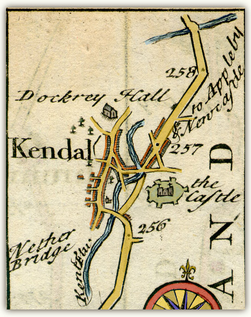
Kendal: Detail from John Owen and Emanuel Bowen Britannia Depicta (1720) 93
Image © Meg Twycross
These strip road maps were advertised as ‘Ogilby Improved’. They concentrate on the route the traveller is to take, with indications only of side roads,
even if they
are fairly major. As a town map, they merely supplement the information in Speed. However, they also supplied concise information about the town from the traveller’s
point of view, conveniently alongside the map:
Kendal at 257 [miles from London] so called from its situation on Kan or Kant Flu [river]. Is a large Town, well built & populous,
driving a Considerable Trade
in the Woollen Manufacture. It had formerly a Strong Castle, the Walls of which are partly yet standing, and has now a large Church, & about 12 Chapels of ease. It
was made a Corporation by Q. Eliz. 18.o. Regni & afterward by K. James 1st 12.o. Regni, consisting of a Mayor, 12 Alderman, 12 Comon
Council men, a Recorder, &c. Here is a good Freeschool well endowed with Exhibitions to Queens Coll. Oxon, Market Saturday, Fairs August
25.th & October 28, & between the said Fairs a great Market for Cattle once a Fortnight.
Owen researchd the information, and Bowen engraved the maps.
Return to top
Detail: Kendal from section 58 of John Cary Cary’s New Map of England and Wales (London: 1794).
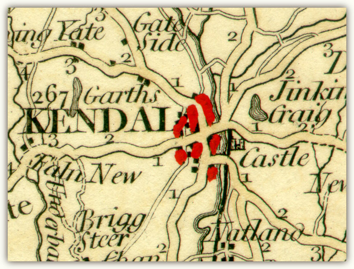
Image © Meg Twycross
Cary’s precision as a surveyor and engraver led to the commission from the Postmaster General in 1794 to survey all the roads of Britain. He also produced some of
the earliest Ordnance Survey maps. The New Map of England is groundbreaking in that it sets out to cover the entire country in contiguous sheets, not bounded by counties as was
traditional. At last the road system is comprehensively covered.
This image is blown up from a section about 25mm wide, so the roads look disproportionately cooked-macaroni-like. Unfortunately in this copy the colourist has obscured the blocks showing the building line, but the layout of the roads
and the spread of housing is clear. He also indicates the distances in miles along the main roads out of Kendal. ‘Faln New’ three miles out of Kendal on the Underbarrow road is in fact
‘Fallen Yew’, the home of the Hubbersty family in the 17th century.
Return to top
Return to Kendal topography index
1. ‘Kirkby in Kendale: 1572-1650’ in Records relating to the Barony of Kendale: volume 1 edited
William Farrer & John F. Curwen (1923) 92-119. Copied from British History Online:
http://www.british-history.ac.uk/report.aspx?compid=49277 Return