
|
|
|
|
|
|
|
|
|
Wensleydale
Click on an image to go to the page.
|
|
|
|
|
|
|
|
|
|
Fox’s actual itinerary here is uncertain, as is the amount of time he spent over it.1 In the Long Journal he seems to imply that he went with Farnsworth from the inn near Pendle Hill towards a town (unnamed — Settle? even Skipton? were Malham or Gargrave large enough to be described as ‘towns’?) where they parted, having spent the previous night sleeping rough on a common. From there (how much later?) he ‘came up Wensleydale’, where ‘at the market town’ (assumed to be Askrigg), he spoke on the market day in the steeplehouse. He then ‘passed up the dales’, meeting with various adventures. His next fixed point is Major Bousfield's in Garsdale, followed by Richard Robinson's at Brigflatts, Gervase Benson’s, and the preaching at Sedbergh on Whit Wednesday. However, sometime before Garsdale he was at James Tennant’s in Langstrothdale, from where he ‘went into Dent’. His memories as recorded in the Short Journal (see the comparison) do not really help.
On Fox’s ministry in Wensleydale, and the comment that he did not spend the night there, see the testimony from Richmond Meeting in The First Publishers of Truth, link above under ‘Other Sources’.
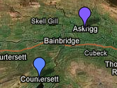
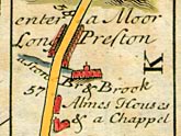
The main route from the South to Wensleydale,2 as shown in the Ogilby route maps and their derivatives, was from Skipton up Wharfedale, through Grassingham, Conistone, and Kettlewell, then up Cam Gill Road, through Coverdale, skirting Great Whernside, to Woodale, Braidley, Horsehouse, Carlton, Melmerby, Agglethorpe, and eventually into Wensleydale at Middleham. Go to the ‘Contemporary Map’ page for a set of conjectural routes sketched out on a modern Google map.
Close Window to return to text
1. See David and Anthea Boulton In Fox’s Footsteps (Dent: Dales Historical Monographs, 1998) pages 61–94, for a suggested and walkable route via Malham. Return
2. For Ogilby’s routemaps, see John Ogilby Britannia, Volume the First: or, an Illustration of the Kingdom of England and Dominion of Wales By a Geographical and Historical Description of the Principal Roads thereof (London: John Ogilby, 1675: facsimile edition, London: Alexander Duckham, 1939). The map concerned is Plate 49. Return