 |
Close
window to return
|
Issue 2, July 1998, pp.6-7.
Area
inequalities in health
Tony Gatrell
Introduction
There is a long and rich tradition in public health, geography and sociology
of exploring the ways in which health and illness are shaped by the areas
in which people live.(1) As Sally Macintyre has noted,(2) it is important
to recognise that health is shaped not only by health behaviours at an
individual level, but also by the quality of the local social and physical
environments within which people live.
The Salford-Lancaster project
The Health Variations programme offers opportunities to those working
in different disciplines to come together to share their perspectives
on health inequalities, and the Salford-Lancaster project brings together
geographers such as myself and sociologists working at both Salford and
Lancaster. We have a particular interest in lay knowledge of health and
illness and lay knowledge of health inequalities. We want to know how
such knowledge is gained and shared with other people. What do people
see as the main determinants of their own health and illness? How do people
perceive differences between themselves and others with regard to the
experience and determinants of ill-health? We believe it is important
to see how these perceptions vary between different areas.
We have therefore chosen to look in depth at four 'localities', two in
Salford and two in Lancaster. One locality in each area is relatively
deprived, the other relatively affluent. Such localities have been carefully
chosen on the basis of Census-derived indicators of deprivation and secondary
data on mortality and illness available from Public Health departments
in the Health Authorities.
Our work is being conducted at three levels. First, we are undertaking
the geographical mapping and analysis of data both on ill-health in these
localities and on access to facilities and services in such areas. Second,
we have conducted, and are about to analyse data from, a survey of households
and individuals in each of the localities. We have data for over 700 people
across the study areas, on their perceptions of service provision, the
quality of the local environment (both physical and social), characteristics
of the home, together with information on health status and views on health.
These data will provide a rich source of material about those living within
quite small neighbourhoods. We will use this as the basis for our third
level of analysis, which will be a series of in-depth interviews with
a small number of people, to explore in much more detail their own experiences
and perceptions of health and inequality. These 'biographical' accounts
will complement the geographical and statistical analyses undertaken earlier.
Here I give the flavour of what our research involves at the first of
our levels of analysis.
Location, health and deprivation
There is a wealth of secondary data that may be used to construct indices
of 'deprivation' at the level of electoral wards, small areas that comprise
typically 5000 people. Wards are also used as the conventional areal unit
for the display and analysis of health data, and there are many examples
of public health reports (including those specifically on health inequalities)
that make good use of such data.(3) However, we need to recognise that
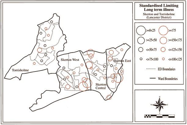
wards may be very heterogeneous, as Figure 1 shows. Each circle represents
an Enumeration District (ED), the smallest unit for which Census data
are provided. Within each of the four wards shown on the map there is
considerable heterogeneity, with some clusters of high morbidity and others
nearby of much lower ill-health. The same is true if we look at those
data used to construct deprivation indices. We need to recognise that,
although useful, areal units such as wards may fail to capture the diversity
of smaller neighbourhoods within their boundaries. Our own localities
have been defined on the basis of groups of EDs.
Figure 1
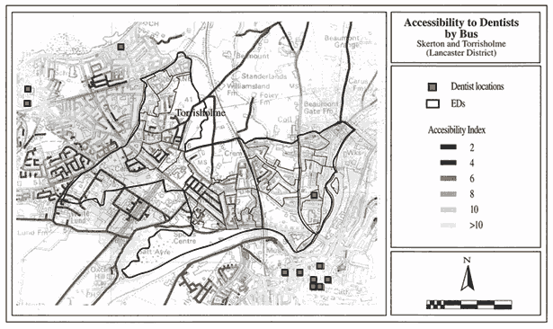
Access to facilities
The use of Census-based 'geodemographic' and health indicators provide
one vehicle for characterising areas, but we need also to know something
about the differential access that those living in small areas have to
health-promoting (as well as health-damaging) features of the local environment.
How accessible, for instance, are sources of good quality and reasonably
priced food, health facilities, leisure and recreational centres? To begin
to tackle such questions we can use detailed information about the locations
of such facilities, and link this to computer-based information on road
networks, including information on bus routes. Looking at the same area
in Lancaster, for example, we can look at differential access to dental
surgeries, which tend to be quite centralised and therefore rather remote
from those needing treatment (Figure 2). We can use similar methods to
explore access by private transport, or on foot, and link this to population
data in order to determine how many people find such facilities relatively
inaccessible. Such information tells us nothing about perceived quality
of services, however, but we can use our survey data and in-depth interviews
to explore these issues more fully.
Figure 2
Tony Gatrell is Director of the Institute for Health Research at Lancaster
University and is part of the project entitled 'Understanding health variations:
the interaction between people, place and time' within the Health Variations
Programme.
References:
1. Macintyre, S. (1998) 'Area inequalities in health', Health Variations
Programme newsletter Issue One pp.6-7.
2. Macintyre, S., Maciver, S. and Sooman, A.. (1991) 'Area, class and
health: should we be focusing on places or people?' Journal of Social
Policy, 22, pp.213-34.
3. Flynn, P. and Knight, D. (1998) Inequalities in Health in the North
West, Warrington : NHS Executive North West.